Offshore Overnight, April 12-13
We have been planning to take VALIS out on an overnight sail for several months, to give the crew a chance to regain (or gain) their sea-legs, and do some open-ocean spinnaker practice. We had agreed on the weekend of April 12-13, and if the weather wasn’t appropriate we would stay in the Bay. As it turned out, the weather was gloriously perfect. The San Francisco Bay Area was forecast to have temperatures in the 70′s and even 80′s, and the winds were unseasonably light, all thanks to a high-pressure system parked overhead. The marine forecast was for winds around 10 kts, with swells 3-6 feet. A low-pressure system would be moving in Sunday night, but we were planning to be back in the slip by sunset Sunday, and the Monday forecast was still reasonable.
The four of us (Alan B, John C, Daniel T, and Paul — me) met for breakfast in Sausalito, then set out under the Golden Gate Bridge. The plan was to work our way north, into the prevailing winds, and position VALIS for a spinnaker run back to San Francisco on Sunday.
Leaving the slip, we put up the main and genoa, and tacked twice out past Point Bonita. The wind was between 8 and 14 kts, and favorable for a close reach out to the Farallon Islands. We decided to pass the south end of the Southeast Farallon Island (because I had never rounded it from that side). As we approached the islands, we witnessed an unusual mirage effect, caused by a thermal inversion, which wildly distorted the Islands. The Southeast Farallon showed strangely truncated peaks and impossible vertical spires. The North Farallons, normally quite impressive, looked even stranger, with needle-like pillars under floating caps.
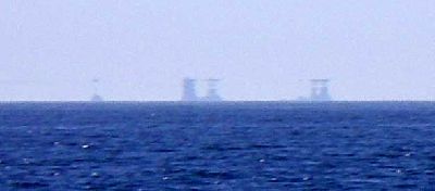
North Farallon Islands
As we approached, the mirages vanished, and we got a great view of the Farallons. Southeast Farallon Island is home to wildlife researchers, and landings are heavily restricted – limited only to support personnel. To visit this rugged island, a ship must moor offshore, and send a dinghy which is hoisted with a derrick onto shore. We were able to see the derrick, the two old houses and newer building, and the cisterns where rain water is stored. The Farallons lighthouse is at the top of the approximately 300 ft “Tower Hill”, and there is a steep trail, with many switchbacks, leading up the hill. Many seabirds make these islands their home, and the downwind odor is quite distinctive.
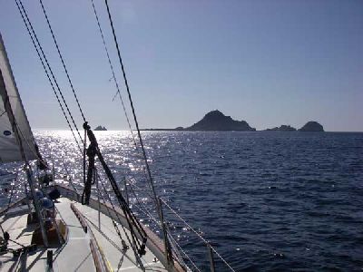
Southeast Farallon Island
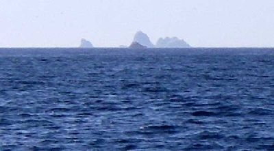
Middle and North Farallon Islands
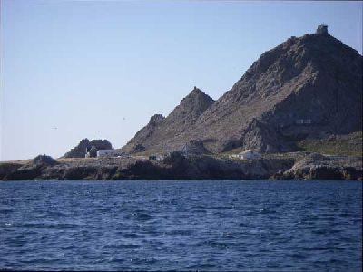
Landing Site
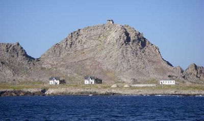
Research Station and Lighthouse
We sailed past Southeast Farallon, and Middle Farallon (not much more than a small rock), then tacked northeast towards Pt Reyes, passing south of the North Farallon Islands around 7:00PM. Dinner was prepared by John: Cup of Noodles for all. At 8:00 we began our formal watches, which we had set at 3 hours, with two watch teams. Paul and Alan stood the first and third watch, Daniel and John having the second and the last.
About 9:00PM we passed within a few miles of the ship “McArthur II”, which triggered the watch alarm on our AIS monitor. Throughout the night we monitored this vessel, as again and again it briefly maneuvered then held position. We speculated about what it was doing in the marine preserve area through which we were sailing, and it’s changing course and speed made us wary that we might find ourselves on a collision course. Around 9:00PM we tacked offshore again, and with the sky darkening we quickly put on extra layers of insulation and our foul weather gear for warmth. The winds remained moderate at about 10 kts and the seas were only a few feet – an easy initiation for Alan, and a gentle re-introduction for the rest of us.
Around 11:30PM we tacked northeast towards Bodega Bay. We were getting colder, but otherwise the conditions were good. We watched the stars, and sailed through several patches of phosphorescent marine life. At 5:30AM (Sunday) we tacked away from Bodega Bay and headed back out to sea. After sunrise we had breakfast (instant oatmeal). Actually, Paul decided to skip the oatmeal and instead took a nap. We again crossed paths with McArthur II around 10:00 AM, and in the light we had a good look at her. She was definitely not a fishing vessel, but appeared to be a workboat or perhaps a research vessel. We normally would have been able to see the Sonoma and Marin county coastline, but there was a thick fogbank obscuring the shore. Offshore it was sunny, and again getting warmer.
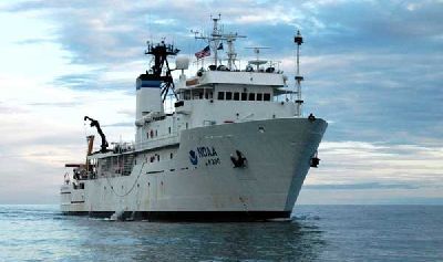
(Image courtesy NOAA website)
Once home I found that McArthur II is a NOAA research vessel:
http://www.moc.noaa.gov/mt/index.html
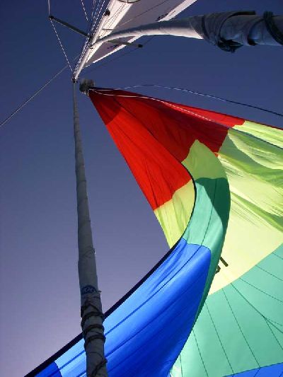
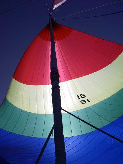
At Noon, we were about 32 nm west of Point Reyes. We had some peanut butter and jam sandwiches, then jibed the boat, pointed towards the Golden Gate Bridge, and set our colorful light-air spinnaker for the run home. We each took turns steering, and getting used to the interplay of wind, sail, swells, and rudder. Windspeed was around 15 kts.
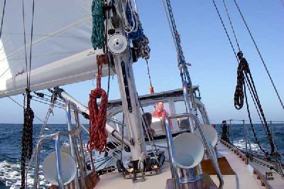
Daniel at the Helm
This is what happens when you don’t pay attention
Back in the groove
Around 2:00PM we were approaching the North Farallon Islands. You can see how the big Pacific waves crash against the western face of these rocks, scrubbing away the otherwise white guano color.
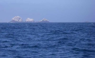
The North Farallons
As we passed these rocks, a fogbank moved in from the west. Limiting visibility to less than a mile. We were getting into crab-pot territory, and had to keep a sharp lookout for the floats and retrieval lines. Around 3:30PM we doused the spinnaker, putting up the genoa in it’s place. We sailed on a deep reach, and as the wind shifted we ran wind and wing, poling out the genoa to port. We were nearing the shipping lane approach channels into San Francisco Bay, so we kept a vigilant watch for other traffic. We were monitoring ship traffic via AIS, but this doesn’t track smaller vessels so we used our eyes and our radar as well.
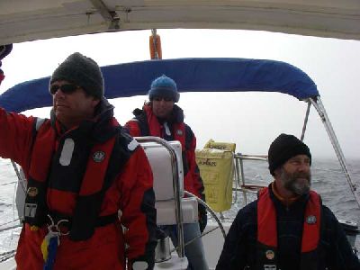
Keeping watch in the fog (L-R: John, Daniel, Alan)
During our approach we found ourselves on a slowly converging course with “Gas Oriental”, a 568 ft tanker. She was invisible in the fog, so we watched the situation on AIS, listened to her foghorn, followed her on radar, and eventually decided to turn north and cross behind her stern. This maneuver completed, we sailed south of Four Fathom Bank, over the bar and into the north side of the channel.
The channel is dredged to 60 ft, but the bar is only 40 ft (and Four Fathom Bank is only 20 ft). The Pacific swells can really stack up when they reach this shallow water, but the seas were small and the flood current helped keep the waves manageable. Still, what had been three-foot swells turned into four-footers with churning whitecaps on top. At Point Bonita, the incoming current and perhaps an outgoing countercurrent created a confused “washing machine”, with wavelets coming from all directions, and eddies that swung VALIS slightly from time to time. The fog began to lift and we could see the Pt. Bonita light and the bases of the Golden Gate Bridge’s north and south towers.
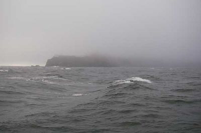
Point Bonita
The bridge deck and above were still obscured by fog. We crossed paths with a tugboat, then dropped the pole, furled the genoa, and sailed under the bridge into the bay as the sun began to set. One jibe, one more freighter, and we were heading towards Richardson Bay and our Sausalito slip. We tied up at 8:00 PM, washed the boat and stowed our gear.
There’s still plenty to do, but this was a good start.
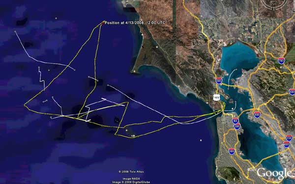
VALIS track (yellow), tracks of McArthur II and Gas Oriental